| GNSS performance | Channels | 220 channels, 336 channels, 692 channels |
| GPS | L1C/A,L1C,L2C,L2E,L5 |
| GLONASS | L1C/A,L1P,L2C/A,L2P,L3 |
| BDS | B1,B2,B3 |
| GALILEO | GIOVE-A,GIOVE-B,E1,E5A,E5B,E6 |
| SBAS | L1C/A,L5 (just for the satellites supporting L5)
QZSS,WAAS,MSAS,EGNOS,GAGAN |
| L-Band | RTX function (336 channels version supports) |
| Positioning output rate | 1Hz~50Hz |
| Initialization time | <10s |
| Initialization reliability | >99.99% |
| Positioning precision | Static surveying | Horizontal: ±3mm+0.1ppm Vertical: ±3.5mm+0.4ppm |
| Code differential positioning | Horizontal: ±0.25m+1ppm Vertical: ±0.50m+1ppm
SBAS positioning accuracy:typically<5m 3DRMS |
| Real-time kinematic surveying | Horizontal: ±8mm+0.5ppm Vertical: ±15mm+0.5ppm (by network)
Horizontal: ±8mm+1ppm Vertical: ±15mm+1ppm (by radio) |
| RTX | Horizontal: 3-10cm (5-30min) Vertical: 8-20cm (5-30min) |
| SBAS positioning | -- |
| xFill | -- |
| IMU tilt compensation | -- |
| Single positioning | -- |
| User interaction | Operaing system | Linux |
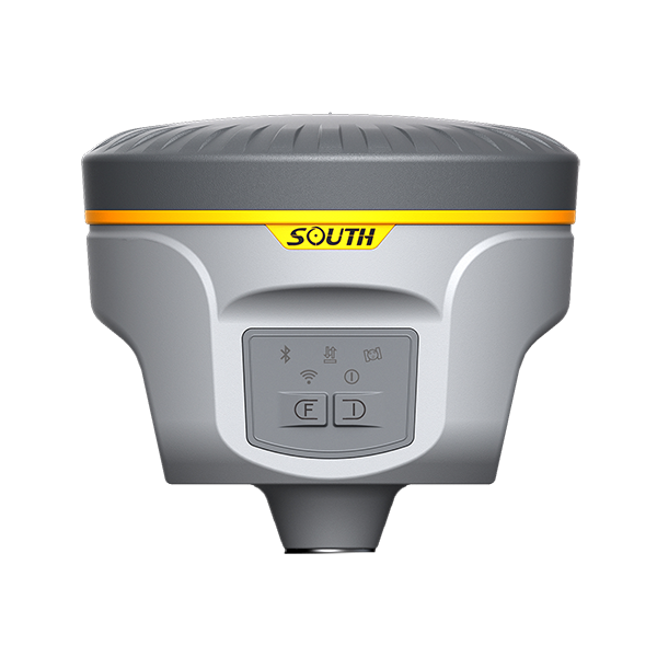
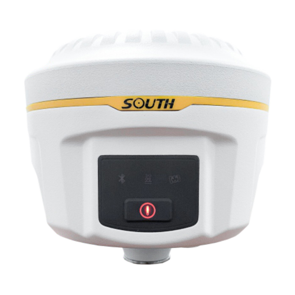
| Buttons | Two buttons operation |
| LCD | -- |
| Indicators | Five indicate lights |
| Web UI | Freely to configure and monitor the receiver by accessing to the web server via Wi-Fi and USB |
| Voice guide | iVoice intelligent voice technology provides status and voice guide
Supporting Chinese, English, Korean, Russian, Portuguese, Spanish, Turkish and user define |
| Secondary development | Providing secondary development package |
| Data cloud service | -- |
| Hardware performance | Dimension | 135mm(Diameter)x125mm(Height) |
| Weight | 1.39kg (with two batteries) |
| Material | Magnesium aluminum alloy shell |
| Operating temperature | -40°C~+65°C |
| Storag temperature | -40°C~+80°C |
| Humidity | 95% Non-condensing |
| Waterproof/Dustproof | IP67 standard, protected from long time immersion to depth of 1m
IP67 standard, fully protected against blowing dust |
| Shock and vibration | Withstand 2 meters pole drop onto the cement ground naturally, comply with MIL-ST0-810F |
| Power Supply | 9-25V DC, overvoltage protection |
| Battery | Rechargeable, removable Lithium-ion battery, 7.4V 3400mAh/per; standard four batteries power package (optional) |
| Battery solution | Supporting one or two batteries installed; supporting power pole connection |
| Battery life | Single battery: >8h (static mode).And two installed hot swappable batteries works for more than 16 hours. |
| Communications | I/O port | 5PIN LEMO external power port + RS232, 7PIN external USB(OTG)+Ethernet
1 radio antenna interface, SIM card slot |
| Wireless modem | Built-in radio, 1W/2W/3W switchable, typically work range can be 8KM
Radio and internet repeater switchable |
| Frequency Range | 410-470MHz |
| Communication Protocol | TrimTalk450s, TrimMark3, PCC EOT, SOUTH |
| Cellular Mobile Network | WCDMA/CDMA2000/TDD-LTE/FDD-LTE 4G network modem, downward compatible with 3G GPRS/EDGE |
| Double Module Bluetooth | BLEBluetooth 4.0 standard, support for android, ios cellphone connection
Bluetooth 2.1 + EDR standard |
| NFC Communication | Realizing close range (shorter than 10cm) automatic pair between receiver and controller
(controller equipped NFC wireless communication module needed) |
| External Devices | Optional external GPRS/EDGE dual-mode communication module, switchable;
allow to connect external WLAN card |
| WIFI | Standard | 802.11 b/g standard |
| WIFI Hotspot | The WIFI hotspot allows any mobile terminal to connect and access to the internal webserver for the control and moditor receiver
|
| WIFI data link | To work as the datalink that receiver is able to broadcast and receive differential data via WIFI |
| Data storage/ Transmission | Data Storage | 8GB SSD internal storage
Support external USB storage and automatical cycle storage
Changeable record interval, up to 50Hz raw data collection |
| Data Transmission | USB data transmission, supporting FTP/HTTP data download |
| Data Format | Differential data format: CMR+, SCMRx, RTCM 2.1, RTCM 2.3, RTCM 3.0, RTCM 3.1, RTCM 3.2
GPS output data format: NMEA 0183, PJK plane coordinates, Binary code, Trimble GSOF
Network model support: VRS, FKP, MAC, fully support NTRIP protocol |
| Inertial sensing system | Tilt survey | -- |
| Electronic bubble | Controller software display electronic bubble, checking leveling status of the centering rod real time
|
| Thermometer | Built-in thermomter sensors, adopting intelligent temperature control technology which can mornitor and adjust the temperature of receiver in real time |